- Software
- - Graphic Apps
- - CAD
- - GEOPoint
GEOPoint 5.0
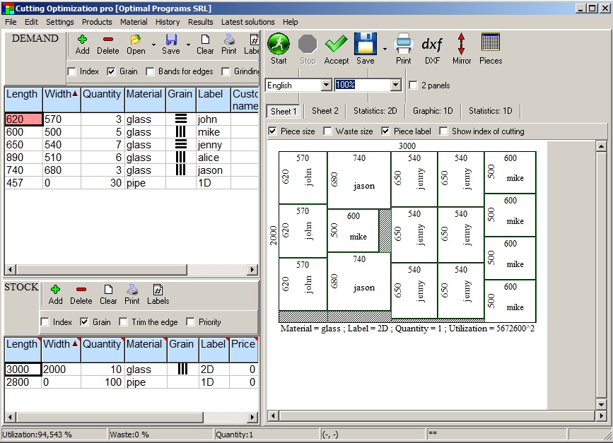
GEOPoint is an easy to use satellite antenna pointing calculator, for geostationary communications satellites. It calculates the azimuth and elevation pointing angles from a given location on the earth towards a specified geostationary satellite. The program also calculates polarisation tilt angles, estimates dates and times of annual sun-outage events, calculates antenna G/T, EIRP and frequency stability, and estimates path-loss and rain-attenuation based on ITU-R climate models. As used by Hausfeld Consulting for satellite communications planning.
Anyone may download and install GEOPoint to access the basic Lite features free of charge.
Lite Features (Free):
an easy to use dialog-style user interface for data entry and calculation;
entry of earth station location coordinates directly, or by clicking on a world map;
select earth station location from a built-in list of world major cities;
display of satellite azimuth and elevation contours on the world map to aid in site selection;
entry of latitude and longitude coordinates in d,m,s format, or as decimal degrees;
entry of coordinates in Australian AMG coordinates and automatic conversion to latitude, longitude;
calculation of pointing angles to a specified satellite for common types of antenna mount;
display of azimuth pointing angles relative to True North, and relative to local magnetic north;
estimation of antenna movement limits for inclined orbit satellites;
calculation of polarisation tilt angle, loop-back path delay, and required antenna tracking speeds;
estimation of the peak dates and times for sun-interference on the receive link.
Output of a summary report in PDF or HTML format.
Pro Features (requires Registration):
ability to zoom the world map one level for more accurate site selection;
ability to save the current map image to file.
ability to save azimuth and elevation contours to a KML file for viewing in Google Earth.
estimation of site altitude from ITU-R world topography model;
select earth station location from a user supplied file containing a list of sites;
view and save a diagram of the GEO Arc visible from the site;
labelling of individual satellites and plotting local horizon and antenna movement limits;
plotting of satellite locations from Norad two-line element or Intelsat ephemeris format orbit data;
display of ITU-R Climate Model data for the specified earth station location;
estimate antenna G/T from user inputs of antenna parameters and frequency;
calculate path loss between the earth station and satellite at a specified frequency using ITU-R propagation models;
estimate the impact of satellite motion on EIRP and frequency stability;
output a batch report of pointing angles from the site, for a list of user selected satellites;
output a detailed report of sun interference dates and times for given receive antenna parameters;
output a detailed report of rain attenuation loss for a range of frequencies and link availability;
output a batch summary report for a list of earth station sites.
| Author | Gunamoi Software |
| License | Demo |
| Price | $50.00 |
| Released | 2023-05-30 |
| Downloads | 481 |
| Filesize | 20.40 MB |
| Requirements | |
| Installation | Instal And Uninstall |
| Keywords | antenna pointing calculator, geostationary communication, antenna calculator, satellite, antenna, calculate |
| Users' rating (17 rating) |
|
| Our rating |

|
Using GEOPoint Free Download crack, warez, password, serial numbers, torrent, keygen, registration codes,
key generators is illegal and your business could subject you to lawsuits and leave your operating systems without patches.
We do not host any torrent files or links of GEOPoint on rapidshare.com, depositfiles.com, megaupload.com etc.
All GEOPoint download links are direct GEOPoint full download from publisher site or their selected mirrors.
Avoid: oem software, old version, warez, serial, torrent, GEOPoint keygen, crack.
Consider: GEOPoint full version, full download, premium download, licensed copy.