Expedition 11.19.23

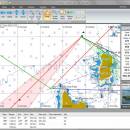
Expedition is a powerful software designed for the ocean navigators that need to plan routes. The program provides you with multiple tools for yacht navigation and can be used successfully for navigation competitions. Expedition’s full potential can be uncovered by actually using it on the water. ...

Author Tasman Bay Navigation System Ltd.
License Demo
Price $1295.00
Released 2023-08-06
Downloads 1273
Filesize 96.60 MB
Requirements
Installation Instal And Uninstall
Keywords yacht navigation, create route, boate course optimization, navigation, yacht, navigator
Users' rating
(35 rating)
ExpeditionCADWindows 8, Windows 8 x64, Windows 10, Windows 10 x64, Windows 11
Expedition map - Download Notice

Using Expedition Free Download crack, warez, password, serial numbers, torrent, keygen, registration codes, key generators is illegal and your business could subject you to lawsuits and leave your operating systems without patches. We do not host any torrent files or links of Expedition on rapidshare.com, depositfiles.com, megaupload.com etc. All Expedition download links are direct Expedition full download from publisher site or their selected mirrors.
Avoid: map oem software, old version, warez, serial, torrent, Expedition keygen, crack.
Consider: Expedition full version, map full download, premium download, licensed copy.

Expedition map - The Latest User Reviews

Most popular CAD downloads

ExpertGPS

8.63 download

... you can draw your route directly on a map, search for nearby features from the millions of ... so you can quickly define an area to map and let ExpertGPS gather the data later. ExpertGPS ...

New Version

TNTmips

20240404 download

... of geospatial data including imagery, terrain surfaces, and map data with associated database attributes. It provides all ... published on the Internet as web tilesets, Web Map Service (WMS), and ArcIMS ... Automatically generate ...

QGIS

3.36.1 download

... database formats and lets you browse and create map data on your computer. QGIS supports many ... On the fly projection of vector layers · Map composer · Identify features · Display attribute table ...

QGIS for Mac

3.36.1 download

... database formats and lets you browse and create map data on your computer. QGIS supports many ... On the fly projection of vector layers · Map composer · Identify features · Display attribute table ...

QGIS for Linux

3.36.1 download

... database formats and lets you browse and create map data on your computer. QGIS supports many ... On the fly projection of vector layers · Map composer · Identify features · Display attribute table ...

DX Central

2.20 download

... different views of the sun · Doppler MDI map of the sun's far side · D-Region X-Ray absorption map from NOAA SWPC · Updates automatically every 10 ...

Expedition

11.19.23 download

... would consider appealing and clear, with a nautical map dominating most of the main application window and the menus and options available in the top part. Expedition’s full potential can ...

Elshayal Smart

23.02 download

... query builder, build network, find shortest path, print map, save map image, copy map image to clipboard, save project map, edit move vertex, edit move features, snap vertexes, ... features, edit data table, modify table structure, edit map features, drawing new features, GPS, 3D, etc... ...

Panoply

5.3.4 download

... Plot lon-lat data on a global or regional map (using any of over 75 map projections) or make a zonal average lineplot. * ... PDF or PostScript graphics files. * Export lon-lat map plots in KMZ format. ...

Panoply for Mac

5.3.4 download

... one plot by differencing, summing or averaging. Create map plots of trajectory data based on the CF ... Plot lon-lat data on a global or regional map using any of over 200 map projections or ...