Doodles 3D 0.76

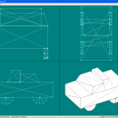
Basic 3D editing program for simple models. Saves to text files for quick editing and importing [model file format]. Point based creation rather than shape creation. Easy to use texture mapping. ...

Author Luigi Pino
License Freeware
Price FREE
Released 2012-06-20
Downloads 192
Filesize 420 kB
Requirements
Installation Instal And Uninstall
Keywords create 3D model, doodle creator, shape designer, create, design, designed
Users' rating
(6 rating)
Doodles 3DCADWindows XP, Windows Vista, Windows Vista x64, Windows 7, Windows 7 x64
Doodles 3D create map - Download Notice

Using Doodles 3D Free Download crack, warez, password, serial numbers, torrent, keygen, registration codes, key generators is illegal and your business could subject you to lawsuits and leave your operating systems without patches. We do not host any torrent files or links of Doodles 3D on rapidshare.com, depositfiles.com, megaupload.com etc. All Doodles 3D download links are direct Doodles 3D full download from publisher site or their selected mirrors.
Avoid: create map oem software, old version, warez, serial, torrent, Doodles 3D keygen, crack.
Consider: Doodles 3D full version, create map full download, premium download, licensed copy.

Doodles 3D create map - The Latest User Reviews

Most popular CAD downloads

ArcReader

10.5.0 B6491 download

... and print maps that are published as Published Map Files (PMF) by the ArcGIS Publisher extension to ... and professionals alike. Zoom, pan, and switch between map and page layout views. Communicate more efficiently with ...

PDF to DWG Converter (Developer License)

2.0 download

... files; 10. VeryDOC PDF to DWG Converter support map colors to layers in CAD drawing; 11. VeryDOC PDF to DWG Converter support option to use LINE instead of POLYLINE in ...

MagicPlot Student for Linux

2.9.3 download

... - Data processing - Multiple axes - Color map plots - Figure templates - Batch processing ...

TNTmips

20240404 download

... of geospatial data including imagery, terrain surfaces, and map data with associated database attributes. It provides all the tools you need to view, create, edit, georeference, interpret, and publish any type of ...

QGIS

3.36.1 download

... and database formats and lets you browse and create map data on your computer. QGIS supports many ... On the fly projection of vector layers · Map composer · Identify features · Display attribute table ...

QGIS for Mac

3.36.1 download

... and database formats and lets you browse and create map data on your computer. QGIS supports many ... On the fly projection of vector layers · Map composer · Identify features · Display attribute table ...

QGIS for Linux

3.36.1 download

... and database formats and lets you browse and create map data on your computer. QGIS supports many ... On the fly projection of vector layers · Map composer · Identify features · Display attribute table ...

Panoply for Mac

5.4.3 download

... the generated arrays. You can: Create color contour plots of geo-referenced latitude-longitude, latitude-vertical, longitude-vertical, ... arrays sliced from 2D or larger multidimensional variables. Create color contour plots of "generic" 2D arrays from ...

TNTmips for Mac OS X

20240111 download

... of geospatial data including imagery, terrain surfaces, and map data with associated database attributes. It provides all the tools you need to view, create, edit, georeference, interpret, and publish any type of ...

PixPlant

5.0.49 download

PixPlant quickly transforms photos into photorealistic PBR materials. Create and edit seamless tiling 3D maps with a variety of easy-to-use tools. ...