Terra Excess 25.1217

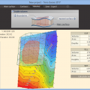
Terra Excess is land surveying and civil engineering software developed to be extremely intuitive. Even by those without previous experience, Terra Excess will allow you to handle the following tasks in just a few minutes - Generating and labeling contour lines in order to produce topographic plans and maps; Calculating accurate volumes of stockpiles and quarries or cut and fill volumes for Earthworks; Viewing and editing survey points. ...

Author Terra Excess Software
License Free To Try
Price $298.00
Released 2017-01-01
Downloads 98
Filesize 46.02 MB
Requirements CPU:1.5 GHz or faster, RAM: 1 GB or more, Disk space: 190 MB, Active internet connection
Installation Install and Uninstall
Keywords land surveying, civil engineering, topographic, contour lines, contour map, triangulated irregular network, earthworks, volumetric, volume calculation, cut and fill, volumes, estimating volumes, survey points, CAD, DXF, quarries, tin surface
Users' rating
(11 rating)
Terra ExcessCADWin2000, Windows XP, Windows 7 x32, Windows 7 x64, Windows 8, Windows 10, WinServer, WinOther, Windows Vista, Windows Vista x64
Terra Excess create map - Download Notice

Using Terra Excess Free Download crack, warez, password, serial numbers, torrent, keygen, registration codes, key generators is illegal and your business could subject you to lawsuits and leave your operating systems without patches. We do not host any torrent files or links of Terra Excess on rapidshare.com, depositfiles.com, megaupload.com etc. All Terra Excess download links are direct Terra Excess full download from publisher site or their selected mirrors.
Avoid: create map oem software, old version, warez, serial, torrent, Terra Excess keygen, crack.
Consider: Terra Excess full version, create map full download, premium download, licensed copy.

Terra Excess create map - The Latest User Reviews

Most popular CAD downloads

Mobile Atlas Creator for Mac OS X

2.2.1 download

... Creator) is an open source (GPL) program which creates offline atlases for GPS handhelds and cell phone ... exported as one large PNG image with calibration MAP file for OziExplorer. As source for an offline ...

Panoply for Mac

5.4.3 download

... the generated arrays. You can: Create color contour plots of geo-referenced latitude-longitude, latitude-vertical, longitude-vertical, ... arrays sliced from 2D or larger multidimensional variables. Create color contour plots of "generic" 2D arrays from ...

PDF to DWG Converter (Developer License)

2.0 download

... files; 10. VeryDOC PDF to DWG Converter support map colors to layers in CAD drawing; 11. VeryDOC PDF to DWG Converter support option to use LINE instead of POLYLINE in ...

PixPlant

5.0.49 download

PixPlant quickly transforms photos into photorealistic PBR materials. Create and edit seamless tiling 3D maps with a variety of easy-to-use tools. ...

TrueSpace

7.61 download

... this release, making it easy for you to create your 3D objects and scenes. ยท The ... real-time engine drives our shared spaces, letting you create immersive online environments with a realism unrivalled in ...

MagicPlot Student

2.9.3 download

... - Data processing - Multiple axes - Color map plots - Figure templates - Batch processing ...

MagicPlot Student for Mac OS X

2.9.3 download

... - Data processing - Multiple axes - Color map plots - Figure templates - Batch processing ...

MagicPlot Student for Linux

2.9.3 download

... - Data processing - Multiple axes - Color map plots - Figure templates - Batch processing ...

Mobile Atlas Creator

2.2.1 download

... Creator) is an open source (GPL) program which creates offline atlases for GPS handhelds and cell phone ... exported as one large PNG image with calibration MAP file for OziExplorer. As source for an offline ...

Doodles 3D

0.76 download

... is a handy application designed to help you create 3D models by adding points and connecting them ... allows you to work with textures and to map them to certain model areas. You can save ...