NemaStudio 1.36.6465.25714

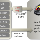
NemaStudio provides the professional developer of NMEA products with a very powerful development and testing tool by simulating the output of various nautical instruments and target objects including GPS, AIS and Radar. All instruments, targets and ports can be matched and mixed, meaning you can have multiple instances of several objects transmitting over the same or over different ports simultaneously. ...

Author Sailsoft
License Demo
Price $364.89
Released 2018-09-05
Downloads 377
Filesize 5.10 MB
Requirements
Installation Instal And Uninstall
Keywords nautical navigation, simulate nautical, navigation simulator, simulate, simulator, nautical
Users' rating
(14 rating)
NemaStudioCADWindows XP, Windows Vista, Windows Vista x64, Windows 7, Windows 7 x64
NemaStudio data editing - Download Notice

Using NemaStudio Free Download crack, warez, password, serial numbers, torrent, keygen, registration codes, key generators is illegal and your business could subject you to lawsuits and leave your operating systems without patches. We do not host any torrent files or links of NemaStudio on rapidshare.com, depositfiles.com, megaupload.com etc. All NemaStudio download links are direct NemaStudio full download from publisher site or their selected mirrors.
Avoid: data editing oem software, old version, warez, serial, torrent, NemaStudio keygen, crack.
Consider: NemaStudio full version, data editing full download, premium download, licensed copy.

NemaStudio data editing - The Latest User Reviews

Most popular CAD downloads

Melanie

9.2.2 download

... comprehensive visualization, exploration and analysis of 2D gel data. It provides powerful and innovative solutions to shorten the path from data acquisition to protein information, both for conventional 2-DE ... interest. It avoids inaccuracies due to manual spot editing and minimizes repetitive match editing tasks. It helps ...

2D/3D cad: dwg, dxf, plt, cgm, svg, pdf

14 download

... its hidden elements and measure them when necessary. Editing. The software has a wide range of tools ... PDF to DWG conversion feature, it transforms PDF data into editable DWG entities. Other types of conversion ...

QGIS

3.36.1 download

... Software (FOSS). QGIS supports vector, raster, and database formats and lets you browse and create map data on your computer. QGIS supports many common spatial data formats (e.g. ESRI ShapeFile, geotiff). QGIS supports plugins ...

Geneious PRO for Vista

4.7.6 download

... suite for manipulating, finding, sharing, and exploring biological data such as DNA sequences or proteins, phylogenies, 3D ... with automated trimming, vector screening, assembly, and chromatogram editing * 454 import and reference assembly with support ...

Geneious PRO

6.0.4 download

... suite for manipulating, finding, sharing, and exploring biological data such as DNA sequences or proteins, phylogenies, 3D ... with automated trimming, vector screening, assembly, and chromatogram editing * 454 import and reference assembly with support ...

Geneious PRO x64

6.0.4 download

... suite for manipulating, finding, sharing, and exploring biological data such as DNA sequences or proteins, phylogenies, 3D ... with automated trimming, vector screening, assembly, and chromatogram editing * 454 import and reference assembly with support ...

CAD6 Industry

2022.1.8.16 download

... post-processor for flexible and efficient generation of CNC data for machine controllers. The CAM plug-in supports the following machining procedures: milling, drilling, turning, water jet cutting, laser cutting, cutting, ...

GPS Utility

5.51 download

... GPS information. You can use it to transfer data to/from a GPS receiver and store the data in PC files in one of several text ... Console. GPS Utility is particularly useful for editing and splicing together track and route segments. You ...

5 award

Translev

4.16.0 download

... of edtiting, formatting and checking digital leveling observation data and creates abstracts, bok files, and VERTOBS datasets for submission to the National Geodetic Survey (NGS). ... corrections and plotting. Also included are routines for editing *.lvl files and VERTOBS files. ...

McCad Schematics

3.8.20 download

McCAD Schematics is a sophisticated engineering database management system that allows the electronic designer to ... principally an on -line system that constructs the databases as the design is created. This process ...