- Software
- - Graphic Apps
- - CAD
- - WindRose PRO
WindRose PRO 3.1.54.0
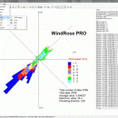
WindRose PRO plots wind roses, minimum, average and maximum values and rays. WindRose PRO is a software for plotting wind roses and other directional data. Data can be loaded as comma separated values (CSV) files or from Excel files. ...
| Author | Enviroware s.r.l. |
| License | Trialware |
| Price | $99.00 |
| Released | 2013-08-22 |
| Downloads | 711 |
| Filesize | 33.10 MB |
| Requirements | |
| Installation | Instal And Uninstall |
| Keywords | plot wind rose, save plot, plot directional data, plot, wind rose, directional |
| Users' rating (28 rating) |
Using WindRose PRO Free Download crack, warez, password, serial numbers, torrent, keygen, registration codes,
key generators is illegal and your business could subject you to lawsuits and leave your operating systems without patches.
We do not host any torrent files or links of WindRose PRO on rapidshare.com, depositfiles.com, megaupload.com etc.
All WindRose PRO download links are direct WindRose PRO full download from publisher site or their selected mirrors.
Avoid: google earth kml oem software, old version, warez, serial, torrent, WindRose PRO keygen, crack.
Consider: WindRose PRO full version, google earth kml full download, premium download, licensed copy.


