3DField 4.6.7.0

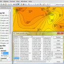
3DField, developed by Vladimir Galouchko, is a powerful visualization tool designed for creating stunning 3D surface plots from your data. Its intuitive interface allows users to easily import datasets and generate detailed maps, making it ideal for scientists, engineers, and researchers. With customizable features, including color gradients and contour lines, 3DField transforms complex data into visually appealing graphics. Whether for presentations or analysis, this software enhances data inte ... ...

Author Vladimir Galouchko
License Demo
Price FREE
Released 2024-08-13
Downloads 804
Filesize 11.50 MB
Requirements
Installation
Keywords surface, map, data visualization, digitize image, mapping software, plotter, surface plot, mapper
Users' rating
(19 rating)
3DFieldEditorsWindows 11, Windows 10 64 bit, Windows 8 64 bit, Windows 7 64 bit, Windows Vista, Windows XP 64 bit
3DField map images - Download Notice

Using 3DField Free Download crack, warez, password, serial numbers, torrent, keygen, registration codes, key generators is illegal and your business could subject you to lawsuits and leave your operating systems without patches. We do not host any torrent files or links of 3DField on rapidshare.com, depositfiles.com, megaupload.com etc. All 3DField download links are direct 3DField full download from publisher site or their selected mirrors.
Avoid: map images oem software, old version, warez, serial, torrent, 3DField keygen, crack.
Consider: 3DField full version, map images full download, premium download, licensed copy.

3DField map images - The Latest User Reviews

Most popular Editors downloads

Pro Motion

NG download

... is a graphic editor, sprite animation and tile map design package, ideal for creating pixel precise animations, images or icons used in games especially for handheld ... container - seamless tile graphic engine - tile map designer - unlimited undo/redo - tons of paint ...

Dynamic Photo HDR

6.1 download

... * Powerful Auto-Aligning, Manual or Auto-Assist Aligning of images with an innovative Pin Warping that can correct ... procedures that can create a whole range of images - from smooth photographic tone mapping to very ...

HDR Expose

2.1.1 build 9804 download

... now as simple as shooting three or more images of varying exposures and then merging those images into one high dynamic range file that reveals ...

Panorama Express Professional

3.0 download

... on the fly panoramic image generation from donut images * multiple still image (standard 2D) scenes * ... the Skin Editor Tab, the Hotspot Tab, the Map & Compass Tab, the Movie Tab, and the ...

Dynamic Photo HDR for Mac

5 download

... * Powerful Auto-Aligning, Manual or Auto-Assist Aligning of images with an innovative Pin Warping that can correct ... procedures that can create a whole range of images - from smooth photographic tone mapping to very ...

Ryijy Stitch Designer

1.4.0 download

... or saved to file with grid or color map. Also own color palettes from DMC colors or from images are supported. Features: Resize and crop ... Own thread palette New color palette creation from images Automatic or manual color reduction Drawing with palette ...

PIE Studio

5.92 download

... and categories * Geotagging of photos with interactive map * Adjust or add EXIF date/time in JPG ... * Paper save mode for maximum number of images on a page * Creation of PDF albums ...

Fhotoroom HDR

3.0.5 download

... RAW (16bit) photos and High Dynamic Range (32bit) Images. Lightroom Export into Fhotoroom HDR Let Fhotoroom ... a few simple steps you can export your images into Fhotoroom, generate a HDR file, tone map ...

WinTopo

1.752 download

... TIF, JPG, PNG, GIF, BMP files and scanned images into useful vector files suitable for CAD, GIS ... Download it right now and start converting your images with the One-Touch Vectorisation button. Features: Load ...

PhotoLocator

2025.6.23.0 download

... management by embedding precise location data into their images. At its core, PhotoLocator offers a user-friendly ... photo libraries, enabling users to sort and search images based on location effortlessly. One of the ...