GreatCirc 4.0

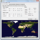
GreatCirc can calculate the Great Circle Distance between any two points on the earth. Also, given a starting point, direction and distance it can calculate the Great Circle End Point. In both cases, GreatCirc will plot the resulting Great Circle path on a world map. ...

Author Gunamoi Software
License Demo
Price $9.95
Released 2024-05-05
Downloads 270
Filesize 6.20 MB
Requirements
Installation Instal And Uninstall
Keywords great circle distance, calculate distance, plotting point, calculator, calculate, circle
Users' rating
(5 rating)
GreatCircCADWindows 7, Windows 7 x64, Windows 8, Windows 8 x64, Windows 10, Windows 10 x64, Windows 11
Our rating 5 award
GreatCirc map of the world - Download Notice

Using GreatCirc Free Download crack, warez, password, serial numbers, torrent, keygen, registration codes, key generators is illegal and your business could subject you to lawsuits and leave your operating systems without patches. We do not host any torrent files or links of GreatCirc on rapidshare.com, depositfiles.com, megaupload.com etc. All GreatCirc download links are direct GreatCirc full download from publisher site or their selected mirrors.
Avoid: map of the world oem software, old version, warez, serial, torrent, GreatCirc keygen, crack.
Consider: GreatCirc full version, map of the world full download, premium download, licensed copy.

GreatCirc map of the world - The Latest User Reviews

Most popular CAD downloads

Metes and Bounds

6.2.1 download

... and Bounds turns data into a deed plot map. It can calculate square feet, acreage and hectares. ... and seconds. Can auto-close a plot drawing if the final plot segment is missing. Calculate area. Custom ...

AutoCAD 2018

2018 download

... Customizable experience Configure your AutoCAD settings, extend the software, and build custom workflows. (video: 1:16 min.) ... features include an updated modern interface that improves the design process and productivity enhancements that help speed ...

TrueSpace

7.61 download

The TrueSpace application was designed to be a fully-featured ... as XNA to develop games for Windows or the Xbox 360. · Also included is an ... you can place whatever you make into real world locations in Virtual Earth and share them with ...

ExpertGPS

8.63 download

ExpertGPS is the ultimate mapping software for Garmin, Magellan, and Lowrance ... USGS topo maps and aerial photos. Using the powerful mapping tools in ExpertGPS, you can draw your route directly on a map, search for nearby features from the millions of ...

GEOPoint

5.0 download

... pointing calculator, for geostationary communications satellites. It calculates the azimuth and elevation pointing angles from a given location on the earth towards a specified geostationary satellite. The program also calculates polarisation tilt angles, estimates dates ...

5 award

Geographic Calculator

2020 SP2 download

The Blue Marble Desktop is now the Geographic Calculator. The modules such as Geographic Transformer and Spatial Connect ... and all functionality from them are available in the Calculator. There is also no more versioning for ...

AutoCAD 2016

download

... Customizable experience Configure your AutoCAD settings, extend the software, and build custom workflows. (video: 1:16 min.) ... features include an updated modern interface that improves the design process and productivity enhancements that help speed ...

AutoCAD 2019

2019 download

... Customizable experience Configure your AutoCAD settings, extend the software, and build custom workflows. Features: ... features include an updated modern interface that improves the design process and productivity enhancements that help speed ...

BimRoad

Plus download

Parametric road design. The world's first software for automatic interchange design. Three-dimensional alignment ... Real-time interchange redesign considering design standards by changing the main alignment. All type of interchange design using ... English/Chinese support. Automatic Three-dimensional converting from two-dimensional digital map. Automatic extraction of GIS information in the digital ...

GreatCirc

4.0 download

... a tool for calculating Great Circle distances on the earth's surface, and plotting points and great circle paths on a world map. The "great circle path" is the shortest direct route ...

5 award