JGPSTrackEdit 1.6.0

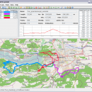
JGPSTrackEdit is a tool for editing gps tracks and planning (multiple days) tours (GPS track editor). An abritary number of tracks may be opened or created, tracks may be merged. A track may be splitted, reversed or edited (e.g. compressed and corrected).
Points may be inserted or appended to a track (routing supported) or may be moved or deleted from a track. ...

Author Hubert Lutnik
License Open Source
Price FREE
Released 2015-02-26
Downloads 328
Filesize 502 kB
Requirements
Installation Instal And Uninstall
Keywords tour planner, create track, GPS track, planner, GPS, track
Users' rating
(7 rating)
JGPSTrackEditOtherWindows XP, Windows Vista, Windows Vista x64, Windows 7, Windows 7 x64
JGPSTrackEdit map - Download Notice

Using JGPSTrackEdit Free Download crack, warez, password, serial numbers, torrent, keygen, registration codes, key generators is illegal and your business could subject you to lawsuits and leave your operating systems without patches. We do not host any torrent files or links of JGPSTrackEdit on rapidshare.com, depositfiles.com, megaupload.com etc. All JGPSTrackEdit download links are direct JGPSTrackEdit full download from publisher site or their selected mirrors.
Avoid: map oem software, old version, warez, serial, torrent, JGPSTrackEdit keygen, crack.
Consider: JGPSTrackEdit full version, map full download, premium download, licensed copy.

JGPSTrackEdit map - The Latest User Reviews

Most popular Other downloads

Hallo northern sky

4.3.2a download

"Hallo northern sky" or HNSKY is a planetarium program for windows. Have a try. It is free with 26000 deepsky objects and all stars to magnitude 12 and with the original ...

Sun and Moon World Map

2.9.0.0 download

This application shows a world map with the position of the Sun and Moon in real-time or in a specific date. In addition, you can see in real-time or accelerated-time ...

Global Mapper

25.1 download

... (DEM) can be loaded with a scanned topographical map to create a 3D view of the map. A digital aerial image can be draped on ... to the complete TerraServer-USA satellite imagery and topographic map archive for the entire US free-of-charge within the ...

Global Mapper x64

25.1 download

... (DEM) can be loaded with a scanned topographical map to create a 3D view of the map. A digital aerial image can be draped on ... to the complete TerraServer-USA satellite imagery and topographic map archive for the entire US free-of-charge within the ...

RV Companion

2.61 download

... automatically check for program updates. • Get a map, print directions, weather, TV listings for any camp with one click. • Browse the Web with the built-in web browser. • ...

D2D Map Editor

2.5.1 Beta download

D2D Map Editor is an open source project written in ... my future game projects. It isn't the best map editing tool compare to others, but it suits ... will be adding new features to the D2D Map Editor as needed in the future. Anyone can ...

Portable Marble

2.2.0 download

... Marble offers different thematic maps: A classroom-style topographic map, a satellite view, street map, earth at night and temperature and precipitation maps. All maps include a custom map key, so it can also be used as ...

GMapCatcher for Mac OS X

0.8.2.1 download

... maps viewer. It downloads CloudMade, OpenStreetMap or Google Map tiles automatically, display them using a specific GUI. User can view the maps while offline. GMapCatcher doesn't depend on google-map's java ...

Diving Log for Windows Phone

4.0.0.0 download

... incl. certifications - Statistics - Divesite Map & Navigation - Nitrox & SAC calculator Supported Languages: English, German, French Trial Limitation: 10 dive limit ...

qMetro

0.7.6 download

qMetro is a vector metro map for calculating route and getting information about transport nodes. Features: view maps search stations search routes description route multilanguage information for ...