PhotoLocator 2025.6.23.0

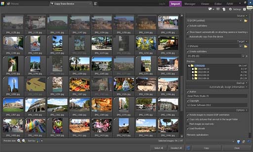
PhotoLocator by MeeSoft is an innovative software designed for photographers and enthusiasts alike, streamlining the process of organizing and managing photo collections. With its intuitive interface, users can easily tag, search, and locate images based on geographical data, ensuring that every shot is just a click away. The software supports various file formats and integrates seamlessly with popular editing tools. Whether you're a professional or a hobbyist, PhotoLocator enhances your workflo ... ...

Author MeeSoft
License Open Source
Price FREE
Released 2025-06-26
Downloads 21
Filesize 2.10 MB
Requirements
Installation
Keywords location, attach GPS tag, geotag, GPS, geotag image, PhotoLocator free download, PhotoLocator, geographical tag, MeeSoft, download PhotoLocator, JPEG, photography, image organization, location tracking, geotagging
Users' rating
(5 rating)
PhotoLocatorEditorsWindows 11, Windows 10 32/64 bit
PhotoLocator map - Download Notice

Using PhotoLocator Free Download crack, warez, password, serial numbers, torrent, keygen, registration codes, key generators is illegal and your business could subject you to lawsuits and leave your operating systems without patches. We do not host any torrent files or links of PhotoLocator on rapidshare.com, depositfiles.com, megaupload.com etc. All PhotoLocator download links are direct PhotoLocator full download from publisher site or their selected mirrors.
Avoid: map oem software, old version, warez, serial, torrent, PhotoLocator keygen, crack.
Consider: PhotoLocator full version, map full download, premium download, licensed copy.

PhotoLocator map - The Latest User Reviews

Most popular Editors downloads

Pro Motion

NG download

... is a graphic editor, sprite animation and tile map design package, ideal for creating pixel precise animations, ... container - seamless tile graphic engine - tile map designer - unlimited undo/redo - tons of paint ...

MeshLab

2023.12 download

... 3D Scanning tools o Alignment ICP based range map alignment tool, for putting meshes into the same reference space. o Merging of multiple meshes the Poisson surface reconstruction source code ...

MeshLab for Mac

2023.12 download

... 3D Scanning tools o Alignment ICP based range map alignment tool, for putting meshes into the same reference space. o Merging of multiple meshes the Poisson surface reconstruction source code ...

Picture Frame Wizard

2.0.0.67 download

... you can visualize the exact location on a map. In case you want to save the location in your photograph, PictureFrame Wizards is your tool to do it. It works ...

RasterStitch x64

4.0 download

... desktop A4 (21x29 cm) scanner or scan a map case of 50x50 cm by individual fragments and then join them to create the whole picture. The stitch line is created ...

Image Constructor

2.5 download

Image Constructor helps you to create original illustrations, structural schemas and diagrams, simple geographical maps and location plants in form of texts and small images over some background with picture or ...

Edraw Max

9.4.1 download

An all-inclusive diagramming software for Windows system that is capable for 260+ drawing types including flowcharts, mind maps, org charts, infographics, floor plans, network diagrams, Gantt charts, electrical schematics... and that ...

3DFieldPro

4.6.7.0 download

3DFieldPro, developed by Vladimir Galouchko, is a powerful and versatile software designed for creating three-dimensional surface maps and contour plots from a variety of data sources. This robust application is tailored ...

easyHDR

3.14.1 download

... The HDR image (also called a HDR radiance map) has to be tone mapped, so it can be displayed on a computer screen or printed. EasyHDR can process TIFFs, JPEGs ...

HoudahGeo

6.4.3 download

... add GPS track logs. * Use the built-in map to assign or adjust photo locations. Use reverse ... * Geocoding without a GPS. Use the built-in map to double-check, adjust, or assign locations * Reverse ...