3DField 4.1.3

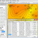
3DField is a contouring plotting and 3D data program. It converts your data into contour maps, surface or volume plots. 3DField allows create the contours (isolines) on surface from regular data set or scattered points. All aspects of 2D or 3D maps can be customized to produce exactly the presentation you want. Rotate image ...

Author Vladimir Galouchko
License Free To Try
Price $99.00
Released 2015-01-21
Downloads 775
Filesize 5.95 MB
Requirements
Installation Install and Uninstall
Keywords map, contour, gridding
Users' rating
(5 rating)
3DFieldCADWin2000, Windows 7 x32, Windows 7 x64, WinOther, WinServer, Windows Vista, Windows Vista x64, Windows XP, Other
3DField png - Download Notice

Using 3DField Free Download crack, warez, password, serial numbers, torrent, keygen, registration codes, key generators is illegal and your business could subject you to lawsuits and leave your operating systems without patches. We do not host any torrent files or links of 3DField on rapidshare.com, depositfiles.com, megaupload.com etc. All 3DField download links are direct 3DField full download from publisher site or their selected mirrors.
Avoid: png oem software, old version, warez, serial, torrent, 3DField keygen, crack.
Consider: 3DField full version, png full download, premium download, licensed copy.

3DField png - The Latest User Reviews

Most popular CAD downloads

TNTatlas for Mac OS X

2024 B20240508 download

... display numerous file formats including shapefiles, GeoTIFF, JP2, PNG, MrSID, DXF, and DWG. Geospatial information plays a growing part in the way we work and live. Maps, drawings, photos ...

Gerbview

10.21 download

... files can be set individually. TIFF, CALS, BMP, PNG and JPEG files can be added to a ... formats include: TIFF, CALS, Adobe PDF, Windows BMP, PNG and JPEG. Add markup using lines, text, rectangles, ...

Gerbview x64

10.21 download

... files can be set individually. TIFF, CALS, BMP, PNG and JPEG files can be added to a ... formats include: TIFF, CALS, Adobe PDF, Windows BMP, PNG and JPEG. Add markup using lines, text, rectangles, ...

TNTatlas

2024 B20240606 download

... display numerous file formats including shapefiles, GeoTIFF, JP2, PNG, MrSID, DXF, and DWG. Geospatial information plays a growing part in the way we work and live. Maps, drawings, photos ...

VeryUtils DWG to Image Converter Command Line

2.7 download

... files to TIF (TIFF), JPG (JPEG), BMP, GIF, PNG, TGA, PCX, EMF and WMF without the need ... * Supports TIF (TIFF), JPG (JPEG), BMP, GIF, PNG, TGA, PCX, WMF and EMF output formats. * ...

Panoply

5.4.1 download

... print or export plots to KMZ, GIF, PDF, PNG, PS, AVI or MOV file format. In addition, ... colorbar. * Save plots to disk GIF, JPEG, PNG or TIFF bitmap images or as PDF or ...

Panoply for Mac

5.4.1 download

... color table. Save plots to disk GIF, JPEG, PNG or TIFF bitmap images or as PDF or PostScript graphics files. Export lon-lat map plots in KMZ format. Export animations as ...

DWG to JPG Converter Any

2010.5.5 download

... files to TIF (TIFF), JPG (JPEG), BMP, GIF, PNG, TGA, PCX, WMF and EMF without the need of AutoCAD. Key Features: 1. Stand-alone utility - AutoCAD NOT required. 2. Convert ...

Total CAD Converter

1.8 download

... convert CAD files to tiff, pdf, bmp, jpeg, png, wmf, dxf. Source formats are dwg, dxf, plt, hgl, hg, hpg, plo, hp, hp1, hp2, hpgl, hpgl2, gl2, prn, spl, cgm, ...

MAGIX 3D Maker

1.0 download

... Export results Export formats: Exports JPEG, GIF, BMP, PNG (including full PNG Alpha Channel), ICO (Icon), CUR (Cursor), animated GIF, ...