QGIS for Linux 3.36.1
QGIS is a professional GIS application that is built on top of and proud to be itself Free and Open Source Software (FOSS).
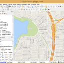
QGIS supports vector, raster, and database formats and lets you browse and create map data on your computer.
QGIS supports many common spatial data formats (e.g. ESRI ShapeFile, geotiff). QGIS supports plugins to do things like display tracks from your GPS.
QGIS aims to be an easy to use GIS, providing common functions and features. The initial goal was to provide a GIS data viewer. QGIS has reached that point in its evolution and is being used by many for their daily GIS data viewing needs. QGIS supports a number of raster and vector data formats, with new support easily added using the plugin architecture.
Here are some key features of "QGIS":
· Support for spatially enabled PostgreSQL tables using PostGIS
· Support for ESRI shapefiles and other vector formats support by the OGR library
· MapInfo files
· GRASS integration, including view, edit, and analysis
· On the fly projection of vector layers
· Map composer
· Identify features
· Display attribute table
· Select features
· Label features
· Persistent selections
· Save and restore projects
· Support for raster formats supported by the GDAL library
· Change vector symbology (single, graduated, unique value, and continuous)
· SVG markers symbology (single, unique value, and graduated)
· Display raster data such as digital elevation models, aerial photography or landsat imagery
· Change raster symbology (grayscale, pseudocolor and multiband RGB)
· Export to Mapserver map file
· Digitizing support
· Map overview
· Plugins
· Improved vector and attribute editing
· Improved measure tools with area measuring
· Attribute searching
· New legend structure
· Refactoring of API to allow the use of QGIS libraries in mapping applications
· Improved MapServer export tool
· Vector layer transparency and antialiasing
· GRASS support in all platforms
· Enhanced GRASS support and toolbox commands
· Enhanced vector editing, including copy, cut, paste, snapping and vertex editing
· Shapefile/OGR layer editing
| Author | Gary Sherman |
| License | Open Source |
| Price | FREE |
| Released | 2024-03-26 |
| Downloads | 290 |
| Filesize | 1.00 MB |
| Requirements | |
| Installation | Instal And Uninstall |
| Keywords | geographic information system, map creator, map viewer, GIS, geographic information, create, QGIS for Linux |
| Users' rating (46 rating) |
Using QGIS for Linux Free Download crack, warez, password, serial numbers, torrent, keygen, registration codes,
key generators is illegal and your business could subject you to lawsuits and leave your operating systems without patches.
We do not host any torrent files or links of QGIS for Linux on rapidshare.com, depositfiles.com, megaupload.com etc.
All QGIS for Linux download links are direct QGIS for Linux full download from publisher site or their selected mirrors.
Avoid: oem software, old version, warez, serial, torrent, QGIS for Linux keygen, crack.
Consider: QGIS for Linux full version, full download, premium download, licensed copy.


