- Software
- - Graphic Apps
- - CAD
- - Terra Excess
Terra Excess 25.1217
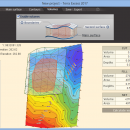
Terra Excess is land surveying and civil engineering CAD software developed to be extremely intuitive. Even by those without previous experience, Terra Excess will allow you to handle the following tasks in just a few minutes - GENERATING AND LABELING CONTOUR LINES IN ORDER TO PRODUCE TOPOGRAPHIC PLANS AND MAPS: Terra Excess can generate contour lines from topographic survey data in a very simple way. All you need to do is select the points with elevation values and create a 'Main surface'. Once done, you should choose the interval and draw the contours. Contour lines in Terra Excess can also be labeled. Generated contours can be used as a base map for designing and implementing various construction projects or creating topographic plans and maps; CALCULATING ACCURATE VOLUMES OF STOCKPILES AND QUARRIES OR ESTIMATING CUT AND FILL VOLUMES FOR EARTHWORKS: By using volumetric survey data (sets of points with elevation data), Terra Excess can accurately calculate stockpile volumes, extraction quantities as well as volumes of earthworks, quarries and more. The software creates a triangulated irregular network (TIN) for the representation of the surfaces and computes the volumes between them by using prism volume calculations. This is the most accurate method for estimating volumes, whose accuracy depends only on the quality of the data entered; VIEWING AND EDITING SURVEY POINTS: Survey points entered in Terra Excess can be clearly visualized and edited. They can be scaled in size and some of their properties can be hidden for instance Number, Elevation or Description; EXPORTING DATA TO DXF: The possibility to export points and contour lines generated in Terra Excess in the DXF file format allows users to transfer the data between various CAD software products.
| Author | Terra Excess Software |
| License | Free To Try |
| Price | $298.00 |
| Released | 2017-01-01 |
| Downloads | 98 |
| Filesize | 46.02 MB |
| Requirements | CPU:1.5 GHz or faster, RAM: 1 GB or more, Disk space: 190 MB, Active internet connection |
| Installation | Install and Uninstall |
| Keywords | land surveying, civil engineering, topographic, contour lines, contour map, triangulated irregular network, earthworks, volumetric, volume calculation, cut and fill, volumes, estimating volumes, survey points, CAD, DXF, quarries, tin surface |
| Users' rating (11 rating) |
Using Terra Excess Free Download crack, warez, password, serial numbers, torrent, keygen, registration codes,
key generators is illegal and your business could subject you to lawsuits and leave your operating systems without patches.
We do not host any torrent files or links of Terra Excess on rapidshare.com, depositfiles.com, megaupload.com etc.
All Terra Excess download links are direct Terra Excess full download from publisher site or their selected mirrors.
Avoid: oem software, old version, warez, serial, torrent, Terra Excess keygen, crack.
Consider: Terra Excess full version, full download, premium download, licensed copy.


