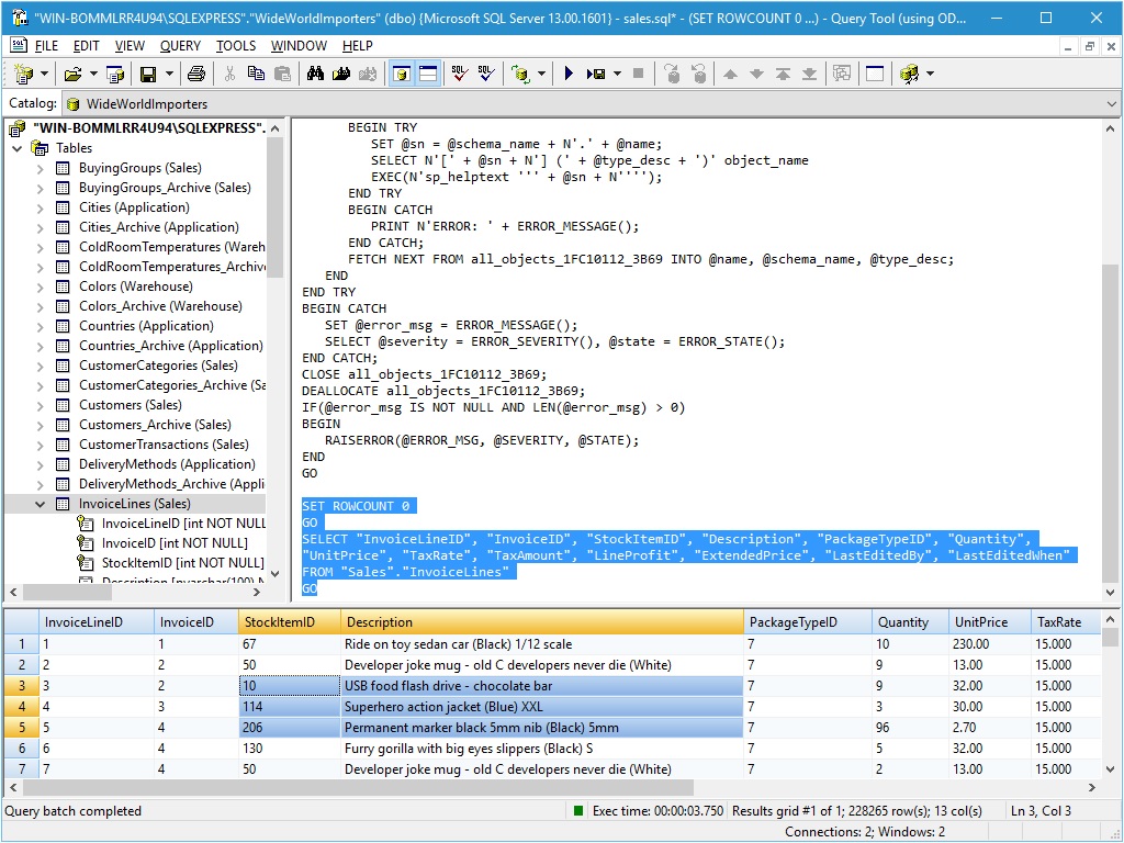
TOPOWIN 20.01

TOPOWIN is a state-wide register of the German topographic cartographies and of localities with geo references in different coordinate systems. It also is a topographic information system. The topographical maps of different standards can be determined by the entering of known parameters or by the direct selection from overview graphics and from sorted lists. ...

Author Killet GeoSoftware Ing.-GbR
License Free To Try
Price $125.00
Released 2021-06-20
Downloads 901
Filesize 4.52 MB
Requirements Pentium, 50 MB HD
Installation Install and Uninstall
Keywords topography, geodetics, geography, corner, box, coordinate, map, guide, TK25, TK50, TK50, TK100, TKUE200, GK5, DGK5, geosoftware, registers, place, topowin, topo, placelist, information, system, measuring
Users' rating
(14 rating)
TOPOWINDatabases & ToolsWin2000, Windows XP, Windows 7 x32, Windows 7 x64, Windows 8, Windows 10, WinServer, WinOther, Windows Vista, Windows Vista x64
TOPOWIN 000 - Download Notice

Using TOPOWIN Free Download crack, warez, password, serial numbers, torrent, keygen, registration codes, key generators is illegal and your business could subject you to lawsuits and leave your operating systems without patches. We do not host any torrent files or links of TOPOWIN on rapidshare.com, depositfiles.com, megaupload.com etc. All TOPOWIN download links are direct TOPOWIN full download from publisher site or their selected mirrors.
Avoid: 000 oem software, old version, warez, serial, torrent, TOPOWIN keygen, crack.
Consider: TOPOWIN full version, 000 full download, premium download, licensed copy.

TOPOWIN 000 - The Latest User Reviews

Most popular Databases & Tools downloads

Web Contact Scraper

6.1 download

Web Contact Scraper is a fully automated software application for gathering targeted business leads for email marketing and general business promotion. You can search and gather thousands of business leads, matching ...

FlexView

1.0.7 download

Get direct access to your data warehouse or database for Microsoft Dynamics, Navision, CRM or other Microsoft SQL Server or MS Access database. Select fields from your tables and data source ...

Import Export Microsoft Office Tool

1.0.0.0 download

Extracting and importing is a major problem. Just think, you could take a text file and import it into a program to get automatic results. The text file will be filtered ...

ORTWIN

17.03 download

ORTWIN is a program for the state-wide inquiry of the localities, postal codes and telephone selections in Germany. It finds postal zip codes, telephone pre selections, coordinates and ground level elevations. ...

Geodata Germany

29.05 download

The database tables contains geodata of the Federal Republic of Germany with geo referenced towns, municipalities, town quarters and other administrative units, postal codes, telephone preselections, nature areas, landscapes, climatic zones ...

TOPOWIN

20.01 download

TOPOWIN is a state-wide register of the German Topographic Cartographies, the German Basic Cartography and of localities with geo references in different coordinate systems. It is also a topographic information system. ...

Wordlist English

3.0 download

Wordlist English for Spellchecker, Wordgames (or others) with over 108,000 words. For privat or commercial use. Integrate it into your application, website, search engine. For Universities, translation agencies (create a basis ...

ORTWIN

21.04 download

ORTWIN is a program for the state-wide inquiry of the localities, postal codes and telephone selections in Germany. It finds postal zip codes, telephone pre selections, coordinates and ground level elevations. ...

Geodata Germany

29.05 download

The database tables contains geodata of the Federal Republic of Germany with geo referenced towns, municipalities, town quarters and other administrative units, postal codes, telephone preselections, nature areas, landscapes, climatic zones ...

Geodata Germany

29.05 download

The database tables contains geodata of the Federal Republic of Germany with geo referenced towns, municipalities, town quarters and other administrative units, postal codes, telephone preselections, nature areas, landscapes, climatic zones ...