TriSpace 2021.24.3.652

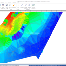
TriSpace is a comprehensive application designed to provide users with a simple means of calculating and viewing terrains.
TriSpace is worth having especially in geological fields due to the extreme facility in creating longitudinal sections.
The aforementioned application also provides you with standard graphic objects such as polygons, arches and rectangles that allow you to indicate perimeters or excluded areas. ...

Author GEOSTRU
License Trialware
Price $500.00
Released 2021-01-21
Downloads 260
Filesize 15.30 MB
Requirements
Installation Instal And Uninstall
Keywords Terrain Calculation, 3D Terrain Viewer, View 3D Surface, Calculation, Terrain, Surface
Users' rating
(10 rating)
TriSpaceCADWindows XP, Windows Vista, Windows Vista x64, Windows 7, Windows 7 x64, Windows 8, Windows 8 x64, Windows 10, Windows 10 x64
TriSpace 2 points - Download Notice

Using TriSpace Free Download crack, warez, password, serial numbers, torrent, keygen, registration codes, key generators is illegal and your business could subject you to lawsuits and leave your operating systems without patches. We do not host any torrent files or links of TriSpace on rapidshare.com, depositfiles.com, megaupload.com etc. All TriSpace download links are direct TriSpace full download from publisher site or their selected mirrors.
Avoid: 2 points oem software, old version, warez, serial, torrent, TriSpace keygen, crack.
Consider: TriSpace full version, 2 points full download, premium download, licensed copy.

TriSpace 2 points - The Latest User Reviews

Most popular CAD downloads

Carlson Design Sailform

1.0.50 download

... in large, intuitive horizontal broadseams. Create reinforcements, reef points, and batten pockets to be cut along with panels on your Carlson plotter/cutter. Mix and match size, molds, and panel layouts ...

TNTmips

20240404 download

... Automatically generate hundreds to thousands of control points using a reference image of the same area; manually add tie points in side-by-side and overlay display modes using a reference image; place control points with coordinates from GPS devices ... Import ...

BricsCad Classic

24.2.06-1 download

... BricsCad, Dimensions can be linked to entity snap points such as endpoints, midpoints and perpendicular. Associative dimensioning applies to both linear and angular dimensions. Layer states let you save ...

TNTmips for Mac OS X

20240111 download

... Automatically generate hundreds to thousands of control points using a reference image of the same area; manually add tie points in side-by-side and overlay display modes using a reference image; place control points with coordinates from GPS devices. Import and ...

PDF to DWG Converter (Developer License)

2.0 download

... support option to use mm coordinates instead of points in DWG or DXF files; 10. VeryDOC PDF to DWG Converter support map colors to layers in CAD drawing; 11. VeryDOC ...

IGES Viewer alias ABViewer

14 download

... between two parallel surfaces, the distance between two points, length of an edge and radius of a circle or a circular arc. Results of measurements are displayed in the special ...

QCAD Portable

3.29.3 download

... Over 20 modification tools Construction and modification of points, lines, arcs, circles, ellipses, splines, polylines, texts, dimensions, hatches, fills, raster images Various powerful entity selection tools Object snaps Measuring tools ...

STL Viewer / ABViewer

14 download

... height between two parallel surfaces, distance between two points, length of an edge and radius of a circle or a circular arc. The results of measurements are displayed in the ...

GreatCirc

4.2 download

... calculate great circle distances and bearings between two points on the globe. This is essential for anyone involved in aviation or maritime navigation, as it provides the shortest path over ...

5 award

QCAD for Mac OS X

3.29.3 download

... Over 20 modification tools Construction and modification of points, lines, arcs, circles, ellipses, splines, polylines, texts, dimensions, hatches, fills, raster images Various powerful entity selection tools Object snaps Measuring tools ...