PowerNet 5.32

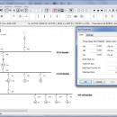
PowerNet is a full-featured electrical engineering design and analysis software for electrical contractors, consultants and other electrical engineering organizations. It is suitable for medium to large projects requiring an easy to implement and easy to use engineering software. Electrical projects such as commercial building services, industrial plants, mining operations, as well as power generation, transmission and distribution systems. ...

Author Megasys Software
License Demo
Price $250.00
Released 2019-11-07
Downloads 286
Filesize 38.00 MB
Requirements
Installation Instal And Uninstall
Keywords circuit analyzer, circuit calculation, power circuit, circuit, analyzer, calculator
Users' rating
(18 rating)
PowerNetCADWindows XP, Windows Vista, Windows Vista x64, Windows 7, Windows 7 x64, Windows 8, Windows 8 x64, Windows 10, Windows 10 x64
Our rating 5 award
PowerNet featured - Download Notice

Using PowerNet Free Download crack, warez, password, serial numbers, torrent, keygen, registration codes, key generators is illegal and your business could subject you to lawsuits and leave your operating systems without patches. We do not host any torrent files or links of PowerNet on rapidshare.com, depositfiles.com, megaupload.com etc. All PowerNet download links are direct PowerNet full download from publisher site or their selected mirrors.
Avoid: featured oem software, old version, warez, serial, torrent, PowerNet keygen, crack.
Consider: PowerNet full version, featured full download, premium download, licensed copy.

PowerNet featured - The Latest User Reviews

Most popular CAD downloads

hsCADView

4.0.134.2 download

... support for industry standard formats. [Proof that fully featured doesn't have to mean pricey] hsCADView is available at casual user prices with expert user features. Get more results with less ...

CADopia 23 Standard

22.3.1.4100 download

CADopia 23 Standard (PERPETUAL license) is a full-featured CAD solution. The advanced features in this edition include ACIS 3D solid modeling, customization tools, PDF to DWG conversion, voice notes, and support ...

TNTmips

20240404 download

TNTmips software is a complete Geographic Information System (GIS) that lets you work with virtually any type of geospatial data including imagery, terrain surfaces, and map data with associated database attributes. ...

CrystalMaker for Mac OS X

11.1.0 download

CrystalMaker provides a streamlined workflow that majors on productivity: just drag-and-drop your data files into the program for instant display in spectacular photo-realistic colour. Manipulate structures in real time, with the ...

CrystalMaker

11.1.0 download

CrystalMaker provides a streamlined workflow that majors on productivity: just drag-and-drop your data files into the program for instant display in spectacular photo-realistic colour. Manipulate structures in real time, with the ...

CADopia 23 Professional

22.3.1.4100 download

CADopia 23 Professional (Perpetual license) is a full-featured CAD solution. The advanced features in this edition include ACIS 3D solid modeling, customization tools, PDF to DWG conversion, voice notes, and support ...

TopSpice

10.26a download

TopSpice is an affordable integrated computer-aided circuit design software package offering advanced native mixed-mode mixed-signal analog/digital/behavioral simulation based on the industry standard SPICE simulator program. TopSpice is a true analog/digital/behavioral ...

HighDesign

2023.1.1.2184.0 download

HighDesign is the full-featured, fast CAD and architectural design solution to create precise drawings, projects, layouts, and work with DWG drawings. Developed specifically for the needs of architects, engineers, and design ...

CADopia 23 Professional

22.3.1.4100 download

CADopia 23 Professional (Perpetual license) is a full-featured CAD solution. The advanced features in this edition include ACIS 3D solid modeling, customization tools, PDF to DWG conversion, voice notes, and support ...

TNTmips for Mac OS X

20240111 download

TNTmips for Mac is a complete Geographic Information System (GIS) that lets you work with virtually any type of geospatial data including imagery, terrain surfaces, and map data with associated database ...