Fluchtplan Creator 14

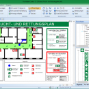
... safety signs (ISO 7010), escape routes and text information required in Germany. Ready templates and examples. Saving ... raster formats: BMP, GIF, TIFF, JPEG. Multifunctional printing system. ...

Author CADSoftTools
License Free To Try
Price $169.00
Released 2018-11-12
Downloads 104
Filesize 38.47 MB
Requirements CPU: 1.33 MHz / RAM: 1 GB / Free disk space: 98 MB
Installation Install and Uninstall
Keywords Fluchtplan Creator, escape plan, escape and evacuation plan, German DIN ISO 23601, escape routes, Flucht- und Rettungsplan, Fluchtplan, Fluchtwegplan, Fluchtplan erstellen, ISO 7010, Brandschutzzeichen, Fluchtwege
Users' rating
(18 rating)
Fluchtplan CreatorCADWin2000, Windows XP, Windows 7 x32, Windows 7 x64, Windows 8, Windows 10, WinServer, WinOther, Windows Vista, Windows Vista x64
Fluchtplan Creator system information tools - Download Notice

Using Fluchtplan Creator Free Download crack, warez, password, serial numbers, torrent, keygen, registration codes, key generators is illegal and your business could subject you to lawsuits and leave your operating systems without patches. We do not host any torrent files or links of Fluchtplan Creator on rapidshare.com, depositfiles.com, megaupload.com etc. All Fluchtplan Creator download links are direct Fluchtplan Creator full download from publisher site or their selected mirrors.
Avoid: system information tools oem software, old version, warez, serial, torrent, Fluchtplan Creator keygen, crack.
Consider: Fluchtplan Creator full version, system information tools full download, premium download, licensed copy.

Fluchtplan Creator system information tools - The Latest User Reviews

Most popular CAD downloads

QGIS

3.36.1 download

... Improved vector and attribute editing · Improved measure tools with area measuring · Attribute searching · New legend structure · Refactoring of API to allow the use of QGIS libraries ...

JMARS for Windows

3.1.5 download

... Analysis for Remote Sensing. It is a geospatial information system (GIS) developed by ASU's Mars Space Flight Facility to provide mission planning and data-analysis tools to NASA's orbiters, instrument team members, students of ...

TNTmips

20240404 download

TNTmips software is a complete Geographic Information System (GIS) that lets you work with virtually any ... with associated database attributes. It provides all the tools you need to view, create, edit, georeference, interpret, ...

Shadow Analyzer

2.2.1.1.1 download

... the products are also good marketing and presentation tools for the negotiations with clients. The '3D View' ... with various forms of the graphical and numerical information concerning your project. They allow you to specify ...

Fluchtplan Creator

14 download

... ISO 23601 2010. The software includes ready drawing tools, safety signs (ISO 7010), escape routes and ready text information (in German) as well as other templates and ... a multifunctional editor that includes not only special tools (wall, door, stairs etc.) but also different CAD ...

Axdea 3D CAD, BIM based IBS Score

1.1.6 download

... Malaysia. Axdea is specially customised for IBS Scoring system based on the Malaysian Construction Industry Standard. As ... software with the following features:- 1) IBS Scoring System: Automatic calculation of IBS score based on the ...

Axdea

1.1.6 download

... Lumpur, Malaysia. Axdea is customised for IBS Scoring system based on the Malaysian Construction Industry Standard. As ... software with the following features:- 1) IBS Scoring System: Automatic calculation of IBS score based on the ...

QGIS for Mac

3.36.1 download

... Improved vector and attribute editing · Improved measure tools with area measuring · Attribute searching · New legend structure · Refactoring of API to allow the use of QGIS libraries ...

TNTmips for Mac OS X

20240111 download

TNTmips for Mac is a complete Geographic Information System (GIS) that lets you work with virtually any ... with associated database attributes. It provides all the tools you need to view, create, edit, georeference, interpret, ...

JMARS

3.1.5 download

... Analysis for Remote Sensing. It is a geospatial information system (GIS) developed by ASU's Mars Space Flight Facility to provide mission planning and data-analysis tools to NASA's orbiters, instrument team members, students of ...