- Software
- - Graphic Apps
- - CAD
- - GHydraulics
GHydraulics 2.1.8
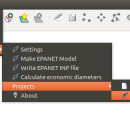
GHydraulics is a Quantum GIS plugin that allows to export water supply networks ... flowrates. The functions are accessible from the Quantum GIS plugin menu and toolbars. ...
| Author | Steffen Macke |
| License | Open Source |
| Price | FREE |
| Released | 2014-04-04 |
| Downloads | 220 |
| Filesize | 932 kB |
| Requirements | |
| Installation | Instal And Uninstall |
| Keywords | Quantum GIS plugin, water supply network, pipe diameter, plugin, Quantum GIS, calculate |
| Users' rating (5 rating) |
Using GHydraulics Free Download crack, warez, password, serial numbers, torrent, keygen, registration codes,
key generators is illegal and your business could subject you to lawsuits and leave your operating systems without patches.
We do not host any torrent files or links of GHydraulics on rapidshare.com, depositfiles.com, megaupload.com etc.
All GHydraulics download links are direct GHydraulics full download from publisher site or their selected mirrors.
Avoid: gis oem software, old version, warez, serial, torrent, GHydraulics keygen, crack.
Consider: GHydraulics full version, gis full download, premium download, licensed copy.


